Enviro News Asia, Jakarta — Indonesia’s National Research and Innovation Agency (BRIN) is developing a national water resources database platform, geophysical mapping technologies, and weather modification technology to strengthen national water security.
The innovations are being developed to support the management of Indonesia’s extensive water resources, which include approximately 5,807 water bodies covering a combined area of around 586,000 hectares.
Acting Head of BRIN’s Research Organization for Earth Sciences and Maritime Affairs, Luki Subehi, said water resource management requires a comprehensive approach because Indonesia’s water resources extend beyond surface water to include atmospheric water, groundwater, coastal groundwater, and alternative water sources.
“Globally, water resources can be grouped into five main categories: atmospheric water resources, surface water, groundwater, coastal groundwater, and alternative water resources,” Luki said during BRIN Goes to Industry 6, themed “Downstreaming Research and Innovation toward Technological Independence and National Water Security,” at the Sarwono Prawirohardjo Science and Technology Center in Jakarta on Thursday (August 27).
Luki said the scale of Indonesia’s water resources requires integrated and continuously updated data. BRIN is therefore developing SiDanau, a national database platform designed to provide information on various types of water bodies, including lakes, reservoirs, retention ponds, and other water storage facilities.
BRIN’s ongoing inventory has identified approximately 5,807 water bodies across Indonesia, covering a total area of around 586,000 hectares. The database is expected to be continuously updated through collaboration with ministries and government agencies, regional administrations, state-owned and regionally owned enterprises, as well as area managers.
“The database is designed to be continuously updated. Its development requires collaboration and participatory support from various stakeholders so that the available information becomes more comprehensive and can be used to support national water resource management,” Luki said.
BRIN is also developing technologies to identify underground water resources in karst areas, aquifers, and underground river systems. Such resources could provide alternative water supplies for communities, particularly in areas facing water shortages and drought risks.
Luki highlighted that water management challenges vary significantly between regions. East Nusa Tenggara, for example, faces limited water availability due to the prevalence of seasonal rivers and a high risk of drought. Pontianak, meanwhile, faces water quality challenges associated with peatland characteristics and tidal influences.
In the karst region of Gunungkidul, water flows largely through underground river systems, requiring specialized approaches to water resource management. In Bali, the sustainability of water resources is closely linked to the condition of catchment areas that influence the quality and availability of water in strategic lakes.
To identify and map underground water resources, BRIN uses several geophysical technologies, including satellite-based remote sensing, electrical resistivity surveys, and seismic surveys. These technologies allow researchers to obtain information about subsurface conditions and identify areas with potential groundwater reserves.
“Geophysical technologies help us understand the presence of water resources that cannot be directly observed at the surface. The results of this mapping have been utilized in various water resource exploration and identification activities in Indonesia,” Luki said.
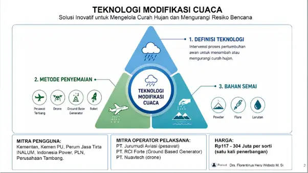
In addition to water resource mapping, BRIN is developing Weather Modification Technology (TMC) as an instrument to increase water availability and support the mitigation of hydrometeorological disasters.
The technology involves intervening in cloud development processes to increase or reduce rainfall, depending on specific requirements and prevailing conditions. It can be implemented through cloud seeding using aircraft as well as ground-based generators.
BRIN is also developing more environmentally friendly and efficient seeding materials designed to improve the absorption of water vapor during cloud seeding operations.
Weather modification technology has been implemented through strategic partnerships with government ministries, state-owned enterprises, and private-sector companies to support water resource management, reservoir replenishment, and hydrometeorological disaster mitigation.
Luki emphasized that future water resource challenges cannot be addressed solely by relying on the availability of natural resources. Scientific research and technological innovation are needed to map, monitor, and optimize water resources in a sustainable manner.
“Indonesia has enormous water resource potential. The challenge ahead is how to utilize geophysical mapping, water resource exploration, and weather modification technologies to strengthen national water security and support disaster mitigation,” Luki said. (*)