Enviro News Asia, Jakarta — The Ministry of Forestry, through the Directorate of Forest Area Designation, has officially launched the Accelerated Digital Transformation Initiative for Inclusive and Responsive Forest Area Information, as part of efforts to strengthen transparent, accountable, and participatory national forest governance.
Director of Forest Area Designation, Donny August Satriayudha D.H., explained that this initiative aims to address long-standing challenges in forest data and information management, which have been fragmented across multiple institutions and lacked full integration.
“This digital transformation seeks to provide comprehensive, accurate, up-to-date, and easily accessible forest area data. This will enable the public to understand the boundaries, functions, and status of forest areas transparently and in real time,” said Donny August Satriayudha in Jakarta, Friday (Oct. 10, 2025).
For more than four decades, forest area designation activities have relied on various mapping methods that evolved over time. However, differences in technology and approach have resulted in varying levels of accuracy, potentially leading to data overlaps, tenure conflicts, and declining public trust in forestry information.
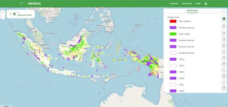
Through an inclusive and responsive digital information system, the Ministry of Forestry is committed to integrating all forest area data into a unified national platform, in line with the One Map Policy and Satu Data Indonesia initiatives. The system will adopt principles of interoperability and openness (open system), allowing cross-agency data access and strengthening intersectoral spatial data collaboration.
The digital platform will not only present information on forest boundaries and functions but also feature a chronological database that records the evolution of forest status and functions over time. This approach is expected to support more targeted, efficient, and evidence-based policymaking.
“We want to ensure that forest area data is not only stored but also optimally utilized for development planning, conflict resolution, and community participation,” Donny added.
The initial implementation phase includes standardizing data provision, developing system features, and integrating data with the Ministry of Agrarian Affairs and Spatial Planning/National Land Agency (ATR/BPN) and local governments. In the next phase, the system will be replicated across 22 Forest Area Consolidation Centers (BPKH) and linked to the National Geoportal.
This digital transformation is expected to significantly improve governance efficiency, accelerate conflict resolution, and enhance public and investor confidence in national forestry data.
“Through openness and data collaboration, we are laying a new foundation for forest area management that is more adaptive, equitable, and sustainable,” Donny concluded. (*)