

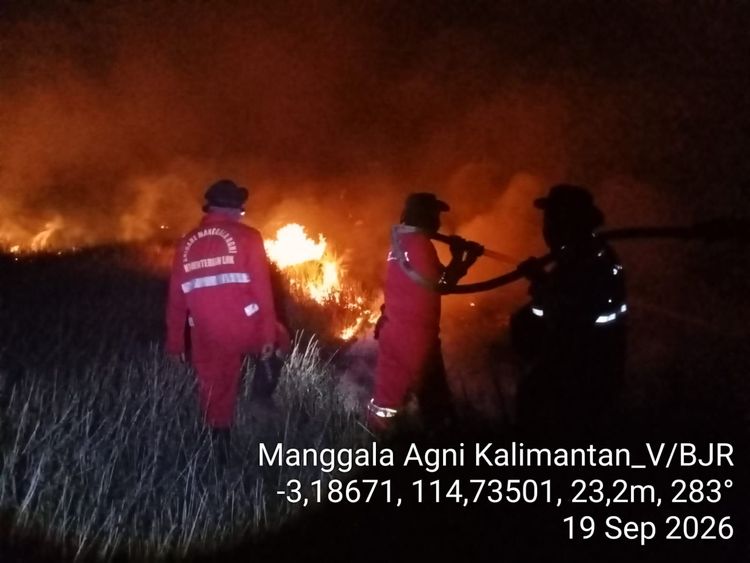
Enviro News Asia, Jakarta — Indonesia recorded a sharp increase in high-confidence forest and land fire hotspots on September 19, 2026, driven mainly by a significant rise in Central Kalimantan, while Riau recorded no high-confidence hotspots in the latest monitoring period.
Data from the Forestry Ministry’s SiPongi system, based on NASA Terra/Aqua, SNPP and NOAA-20 satellite observations, recorded 1,323 high-confidence hotspots nationwide as of 11:59 p.m. local time on September 19. The figure increased by 777 hotspots from 546 recorded on September 18.
Among the six priority provinces for forest and land fire control, Central Kalimantan recorded the largest increase, with 1,035 hotspots compared with 166 the previous day.
South Sumatra recorded 112 hotspots, up from 100, while West Kalimantan rose to 107 from 39. South Kalimantan increased to 55 from 12, and Jambi rose to 14 from nine.
Riau was the only priority province to record a decline, with zero high-confidence hotspots compared with four on September 18.
The Forestry Ministry said the sharp increase in Central Kalimantan had made the province the main focus of strengthened fire-control operations. Authorities have also increased vigilance in West Kalimantan and South Kalimantan.
The ministry stressed that satellite-detected hotspots represent surface temperature anomalies and cannot automatically be equated with individual fires or the total area burned. A single fire can generate several hotspot detections, making field verification essential.
Manggala Agni personnel from the Forestry Ministry, together with the military, police, BNPB, BMKG, regional disaster management agencies, local governments, communities, businesses and volunteers, are conducting patrols, ground checks, direct firefighting, fire containment, wetting, mopping up and cooling operations.
A total of 55 aircraft are currently supporting fire-control operations across Sumatra and Kalimantan. The fleet includes patrol helicopters, CASA aircraft for weather modification operations and water-bombing helicopters.
Authorities are adjusting aircraft deployment based on fire locations, hotspot developments, cloud potential, smoke conditions, visibility and flight safety.
In peatland areas, operations continue even after surface fires are extinguished. Firefighters carry out wetting and cooling because embers can remain below the surface and reignite when conditions become drier or winds strengthen.
The ministry is also monitoring air quality alongside fire conditions. PM2.5 levels remain variable across Indonesia, with most areas recording good to moderate conditions, while several locations in Sumatra and Kalimantan have reached unhealthy to very unhealthy levels, with some areas classified as hazardous.
Smoke has also affected visibility in parts of Kalimantan. On September 19, visibility in Palangka Raya fell to around 350 meters in the morning, affecting flight operations. Conditions later improved, although smoke remained present. Visibility in Pontianak also fell below one kilometer during the observation period due to smoke.
The ministry said visibility can change rapidly depending on smoke concentrations, wind direction and speed, humidity, rainfall and fire activity. These conditions are also considered when determining whether aerial operations can be conducted safely.
Authorities have urged residents in smoke-affected areas to monitor air-quality information and follow local government guidance. People are advised to reduce outdoor activities when air quality deteriorates and wear masks when outdoor activity is necessary.
Children, pregnant women, older people and individuals with respiratory problems or chronic diseases require particular attention during periods of poor air quality.
Road users have also been advised to reduce speed, switch on vehicle lights and maintain a safe distance when visibility declines.
The Forestry Ministry has reiterated its call for communities and businesses not to clear or open land by burning. Residents are encouraged to report smoke, fires, burning activities or wildlife affected by fires so authorities can respond at an early stage. (*)