


Enviro News Asia, Jakarta — Indonesia recorded 118 high-confidence fire hotspots on Oct. 28, an increase of 39 from the previous day’s 79, while six priority provinces for forest and land fire prevention reported no detected hotspots for the second consecutive day, according to the Forestry Ministry.
Data from the ministry’s SiPongi monitoring system, based on NASA Terra/Aqua, SNPP and NOAA-20 satellite observations at 9 p.m. local time, showed that South Papua accounted for the largest share, with 84 hotspots. East Kalimantan followed with 24, South Sulawesi with five, Central Sulawesi with four and West Sulawesi with one.
The six priority provinces with zero high-confidence hotspots were Riau, Jambi, South Sumatra, West Kalimantan, Central Kalimantan and South Kalimantan.
The Forestry Ministry cautioned that satellite hotspot readings should be assessed alongside conditions on the ground. Hotspots indicate surface-temperature anomalies detected by satellites and cannot be directly equated with the number of fires or the total area burned. Field inspections, patrols and ground checks therefore remain essential.
South Papua, which recorded the highest number of hotspots, is currently under an emergency response status for forest and land fires until Nov. 28, 2026, according to the ministry’s command post report.
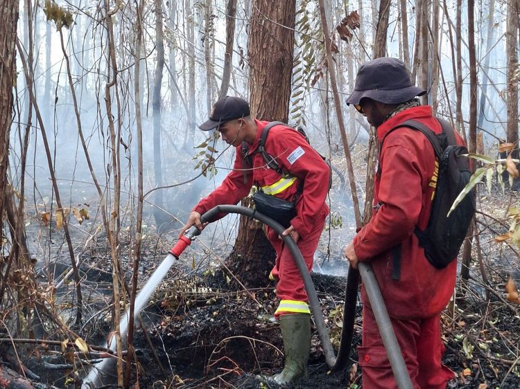
Field operations continued in several provinces despite the absence of high-confidence satellite detections in priority areas. In Jambi, fires in Simpang Terusan, Batang Hari, had been extinguished. However, firefighting continued in Simpang Datuk, East Tanjung Jabung, and Tanjung Village, Muaro Jambi, where fires in peatland areas had not been fully brought under control.
In South Sumatra, a fire in Timbangan, Ogan Ilir, had been extinguished, while joint teams continued tackling underground peat fires in Talang Rimba, Ogan Komering Ilir. Moderate to heavy rain fell during the afternoon, but further suppression was still required.
Manggala Agni firefighters from the Forestry Ministry worked with the military, police, fire prevention teams and other agencies to contain the blaze by establishing firebreaks, stopping its spread and attacking it from several directions.
In South Kalimantan, teams conducted suppression operations in Landasan Ulin Barat, Banjarbaru. The fire in the affected area had been brought under control, although thick smoke remained visible in several locations, requiring continued monitoring.
East Kalimantan recorded 24 high-confidence hotspots in the latest satellite monitoring. However, a fire in Sambaliung, Berau district, had been fully extinguished by a joint team involving Manggala Agni, local firefighters, the military, police, disaster response volunteers and other personnel.
Firefighting operations also continued in Central Sulawesi, particularly in Berdikari Village, Sigi district, and Matialemba Village, Poso district. Fires at both locations had not been fully extinguished by the latest report.
The ministry stressed that the absence of satellite-detected hotspots does not necessarily mean all flames and embers have been extinguished. In peatlands, fires can persist and spread underground even when they are no longer detected by satellites.
Teams are therefore continuing to wet affected areas, search for remaining embers, conduct mopping-up operations and cool fire-prone locations until they are declared safe.
A total of 61 aircraft have been deployed to support firefighting operations. The fleet comprises 24 aircraft for patrols, CASA operations and weather modification, as well as 37 helicopters for water bombing.
Forestry Minister Raja Juli Antoni has urged authorities to make the most of rainfall expected through early November to increase land and peatland wetting. After that period, joint patrols will be strengthened to prevent fires from re-emerging, particularly in vulnerable areas and peatland zones.
He delivered the directive during an inspection of firefighting operations in Jambi on Oct. 27, alongside local government officials, military and police representatives and other stakeholders.
The Forestry Ministry’s Manggala Agni teams continue to coordinate with the National Disaster Mitigation Agency (BNPB), the military, police, the Meteorology, Climatology and Geophysics Agency (BMKG), regional disaster management agencies, local governments, community fire groups, businesses and volunteers.
Their activities include patrols, ground checks, direct firefighting, firebreak construction, land wetting, ember searches, mopping-up operations and cooling, depending on conditions at each site.
The ministry said the success of fire control should not be measured solely by whether hotspot numbers rise or fall. The key priorities are ensuring that flames and embers are fully extinguished, preventing fires from recurring, reducing smoke pollution, protecting communities and safeguarding forests and biodiversity. (*)