Enviro News Asia, Bandung — Indonesia’s forest and land fires in 2026 have contributed to cross-border haze in Southeast Asia, prompting researchers at the National Research and Innovation Agency (BRIN) to map the distribution of fine particulate matter, or PM2.5, and identify major emission source areas.
Researchers from BRIN’s Research Center for Climate and Atmosphere (PRIMA) used atmospheric modeling to examine how PM2.5 emitted by fires can travel across national borders. The study was presented by PRIMA junior researcher Ardhi Adhary Arbain during the center’s Coffee Morning knowledge-sharing forum.
Ardhi said PM2.5 is a fine particle that can penetrate deep into the respiratory system. When transported by wind across national boundaries, the pollutant can become a form of transboundary air pollution.
The research team used WRF-Chem, an atmospheric model that combines meteorological simulations with atmospheric chemistry processes. Fire-emission data were incorporated with meteorological information, while remote-sensing data from Sentinel and MODIS/VIIRS were used to develop a PM2.5 emissions inventory.
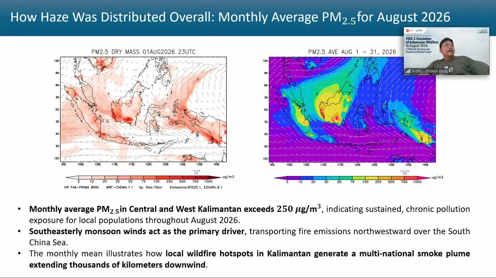
Initial simulations showed that wind direction and speed played an important role in determining areas affected by fire-related PM2.5. In August 2026, prevailing winds generally moved from the southeast before turning northeast after crossing the equator.
The pattern indicated that PM2.5 from fire sources in Indonesia could be transported toward Malaysia, Singapore, Brunei Darussalam, the Philippines and Thailand.
The simulations also showed high PM2.5 concentrations in several source areas, particularly in Kalimantan, Sumatra and Papua. In some areas close to fire sources, simulated concentrations exceeded 7,500 micrograms per cubic meter, while the maximum simulated value at certain locations exceeded 12,000 micrograms per cubic meter in late August.
Compared with August 2015, the 2026 simulation showed a more localized PM2.5 distribution, although concentrations at several source areas were estimated to be higher. The study also indicated that South Papua may have made a more significant contribution to PM2.5 emissions than in 2015.
Ardhi emphasized that the findings remain part of ongoing research and have not yet been fully validated. The simulations have not been comprehensively compared with field observations, meaning the reported concentrations and distribution patterns should not be interpreted as measurements of actual air quality at specific locations.
The research team is also developing alternative modeling approaches to improve simulation efficiency. One approach involves the offline CHIMERE chemical model, which allows meteorological and chemical processes to be modeled separately and provides greater flexibility.
The PM2.5 study was among the research topics shared during PRIMA’s Coffee Morning forum. PRIMA Head Albertus Sulaiman said the forum serves not only as a knowledge-sharing platform but also as a mechanism for coordinating research activities among researchers at the center. (*)