Enviro News Asia, Jakarta — Indonesia’s Ministry of Forestry is strengthening forest and land fire control operations in Central Kalimantan and West Kalimantan following a sharp increase in high-confidence hotspots detected across the country.
The Ministry recorded 1,271 high-confidence hotspots nationwide as of 9:10 p.m. on October 2, 2026, according to its SiPongi forest and land fire early detection system. The figure increased by 689 hotspots from 582 recorded a day earlier.
The hotspots were detected by NASA Terra/Aqua, NASA SNPP and NASA NOAA-20 satellites.
Central Kalimantan recorded the highest number among six priority provinces, with 355 hotspots, up from 205. West Kalimantan followed with 246, after recording no high-confidence hotspots the previous day.
South Sumatra recorded 83 hotspots, up from 78, while South Kalimantan declined to 42 from 63. Riau recorded no hotspots, down from two, while Jambi remained at zero.
Combined, the six priority provinces recorded 726 high-confidence hotspots, more than double the previous day’s 348.
The Ministry stressed that satellite-detected hotspots indicate surface temperature anomalies and do not represent the number of fires or the total area burned. A single fire can generate multiple hotspot detections, making ground verification necessary to determine actual conditions and appropriate field responses.
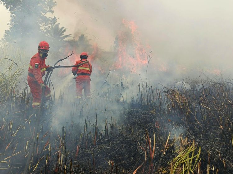
Ground and aerial operations have been intensified through coordinated efforts involving the Ministry’s Manggala Agni fire brigades, the National Disaster Management Agency (BNPB), Indonesian Military (TNI), National Police (Polri), Meteorology, Climatology and Geophysics Agency (BMKG), regional disaster agencies, local governments, communities, volunteers and businesses.
A total of 61 aircraft remain on standby. Seventeen aircraft are assigned to patrols and weather modification operations, while 44 are deployed for water bombing.
Ground teams are conducting patrols, hotspot verification, direct firefighting, firebreak operations, wetting, mopping up and cooling. Particular attention is being given to peatland fires because embers can persist and spread beneath the surface even after visible flames have diminished.
The Ministry is also monitoring air quality to protect communities affected by smoke. PM2.5 monitoring indicates that most areas remain within good to moderate categories, although several areas in Sumatra, Kalimantan, Java and Papua have recorded unhealthy to very unhealthy conditions.
Some areas of Kalimantan have also recorded pockets of hazardous air quality. Authorities said conditions can change rapidly depending on fire activity, air-mass movement, wind direction and speed, and other atmospheric factors.
People in affected areas are advised to follow official air-quality information and local government guidance. If air quality deteriorates, residents should reduce outdoor activities and use masks when going outside. Particular attention should be given to children, pregnant women, older people and those with respiratory or chronic illnesses.
Forest and land fires can also disrupt wildlife habitat, food sources and movement corridors. The Ministry, through the Natural Resources Conservation Agency (BKSDA) and related units, is continuing to monitor and respond to wildlife affected by fires.
Reports involving affected wildlife are first verified and assessed in the field to determine the animal’s condition and the appropriate intervention.
The public is advised not to handle or evacuate injured, trapped or displaced wildlife independently. People should maintain a safe distance, avoid actions that could cause animals to become stressed or aggressive, record the location and condition if possible, and immediately report the situation to the nearest BKSDA or forestry officer.
The Ministry also urged communities and businesses not to clear or prepare land by burning. Early reports of smoke, fires or burning activities can help authorities verify conditions and respond before fires spread further. (*)