Enviro News Asia, New York — A catastrophic flood and landslide along the Nepal-China border has highlighted the growing risks facing communities in the Himalayas as climate change transforms glaciers, permafrost, and mountain slopes.
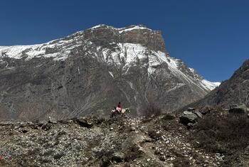
The disaster occurred on August 26, when a massive section of ice and rock collapsed high in the Himalayas and sent water, sediment, and boulders into rivers below. The resulting torrent swept through towns and villages along a major trade corridor connecting Nepal and China.
Seismic monitoring initially registered the mountain collapse as a magnitude 5.2 event because of the scale of the movement. A huge mass of ice and rock traveled approximately 1,200 meters toward the valley floor before triggering a destructive cascade downstream.
At one monitoring station, water levels rose by as much as nine meters within 30 minutes.
By August 28, more than 500 people had reportedly died across Nepal and Tibet, while more than 1,500 people remained missing, including hundreds of foreign nationals.
Scientists are still investigating the precise sequence that triggered the disaster. Satellite imagery indicates that bedrock beneath a glacier failed, sending ice and rock into the Lhende Khola, a tributary of the Bhotekoshi River.
Researchers are also examining whether the resulting debris temporarily blocked the river before the obstruction collapsed, although that sequence has not yet been confirmed.
The event differs from a glacial lake outburst flood, in which water accumulated around retreating glaciers is suddenly released after an unstable natural dam fails.
Research by scientists working with the United Nations University’s Global Mountain Safeguard Research programme, or GLOMOS, has found that glacial lake outburst floods have become substantially more frequent.
An analysis of 493 such events recorded from the earliest available data through 2024 found that their frequency has increased approximately fivefold since 1950, rising from an average of about seven events per decade to 34.
Although scientists have not established that climate change directly caused the August 26 mountain collapse, global warming is rapidly changing the high-altitude environment in which such disasters occur.
As glaciers retreat and permafrost thaws, rocks that were previously stabilized or bound by ice can become increasingly unstable. Growing volumes of meltwater can also contribute to the weakening of mountain slopes.
The risks extend far beyond the immediate disaster zone. The Hindu Kush Himalaya supplies water to 10 major river basins on which approximately 2.1 billion people depend for water, food, energy, and livelihoods.
At the same time, human development is increasingly concentrated in vulnerable mountain valleys.
According to climate researcher Dipesh Chapagain of the United Nations University, communities in Nepal’s mountainous regions historically built homes higher on slopes while using flatter areas near rivers for agriculture.
Economic development has gradually changed that pattern. Roads, businesses, hotels, hydropower facilities, and other infrastructure have increasingly expanded into river valleys because of easier construction and greater economic opportunities.
In some higher-altitude settlements, declining water availability has also encouraged people to move toward lower elevations.
The result is an increasingly dangerous overlap between changing mountain conditions and growing populations and infrastructure in flood-prone valleys.
The Bhote Koshi-Trishuli corridor affected by the latest disaster is a major example. The area contains important trade routes toward Kathmandu as well as hydropower facilities, bridges, roads, hotels, and settlements.
The flooding damaged power infrastructure and disrupted transportation and communications across the region.
The same river system had already experienced a glacial lake outburst flood in the previous year, killing nine people and leaving 24 others missing.
The latest disaster has also raised concerns about the limited time available to warn communities when hazards originate high in the mountains.
Authorities reportedly became aware of the approaching flood only when it was nearing the border. Warnings were subsequently communicated downstream through text messages, social media, telephone calls, and alarms.
Experts say stronger monitoring and early-warning systems are essential to reduce future losses.
Continuous observation of glaciers and unstable slopes, satellite monitoring, weather stations, river gauges, and reliable early-warning systems could provide communities with critical additional time to evacuate.
Because rivers and glaciers cross national borders, experts also emphasize the importance of rapid data-sharing and coordinated disaster preparedness among China, Nepal, and countries farther downstream.
Even a sharp reduction in greenhouse gas emissions would not immediately stop glacier loss. Ice masses will continue to respond to warming already locked into the climate system for decades.
However, the extent of future glacier loss remains influenced by humanity’s ability to reduce emissions.
For communities living beneath the Himalayas, the latest disaster demonstrates that climate adaptation is no longer simply preparation for a distant threat. Increasingly unstable mountain environments are already creating immediate risks to lives, infrastructure, and livelihoods. (*)