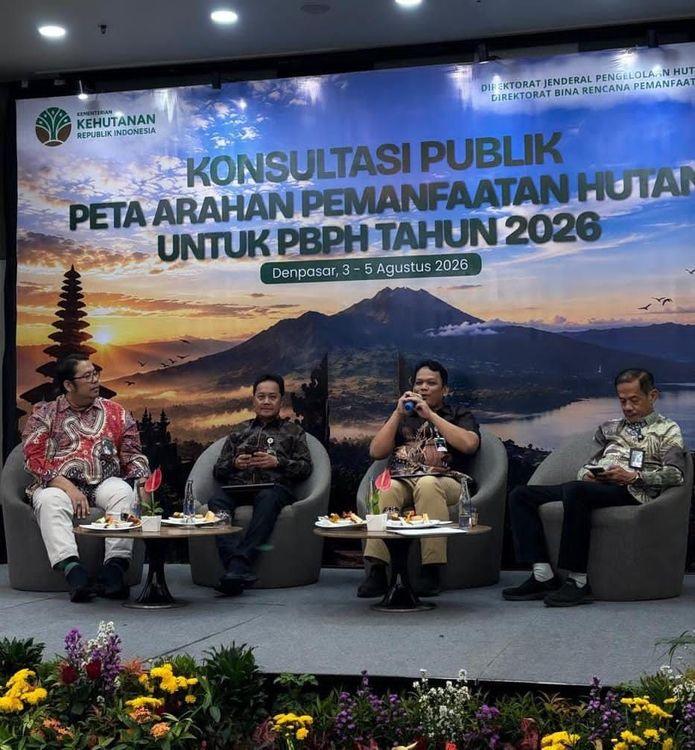
Enviro News Asia, Bali – Indonesia’s Ministry of Forestry is strengthening transparent, adaptive, and data-driven forest governance through the preparation of the 2026 Forest Utilization Directive Map (Peta Arahan Pemanfaatan Hutan/PAPH), which will serve as the basis for Forest Utilization Business Licensing (PBPH). As part of the process, the Directorate of Forest Utilization Planning (BRPH) under the Directorate General of Sustainable Forest Management (PHL) held a public consultation in Bali to gather input from key stakeholders.
The initiative reflects the policy direction of Minister of Forestry Raja Juli Antoni, who has emphasized transparency, legal certainty, and the digitalization of spatial data in national forest governance. The minister has underscored that forest allocation should be managed through an open, accountable, and science-based approach to reduce tenure conflicts while balancing ecosystem protection, community economic development through Social Forestry, and national priorities, including food and energy security.
The consultation brought together approximately 90 participants representing provincial forestry and environmental agencies, Regional Sustainable Forest Management Offices (BPHL), technical units of the Ministry of Forestry, directorates under the Directorate General of Sustainable Forest Management, related government institutions, and the Indonesian Forest Concession Holders Association (APHI).
Director of Forest Utilization Planning C. Hendro Widjanarko said the public consultation was a crucial stage to ensure that the 2026 directive map is developed transparently while accommodating input from multiple stakeholders.
“The Forest Utilization Directive Map is an indicative map established by the Minister as the primary reference for issuing forest utilization licenses in both protected and production forests. Public consultation is therefore essential to produce high-quality policies that provide legal certainty while supporting sustainable forest development,” Hendro said.
The proposed 2026 map covers approximately 5.67 million hectares, consisting of around 1.33 million hectares of protected forests and 4.34 million hectares of production forests. The map has been prepared by incorporating the National Forestry Plan (RKTN), the Indicative Map for the Suspension of New Licenses (PIPPIB), thematic geospatial information, and stakeholder recommendations.
According to Hendro, the directive map will not only guide the issuance of forest utilization licenses but also provide greater certainty for prospective investors regarding areas available for licensing while supporting national strategic priorities, including food and energy security. The map will also serve as a reference for provincial governors in issuing recommendations for forest utilization permits.
Director of Forest Area Management Planning and Forest Management Unit Development Beni Raharjo stated that the preparation of the directive map directly implements the revised National Forestry Plan 2011–2030.
“The National Forestry Plan promotes integrated, optimized, and sustainable landscape governance. Therefore, the directive map must remain aligned with national policy to ensure that forest utilization maintains an appropriate balance between ecological, social, and economic functions,” he said.
Beni added that the national forestry strategy also allocates space for social forestry, forest rehabilitation, ecosystem protection, non-forestry activities, and the development of community-based and corporate forestry enterprises.
Meanwhile, Director of Forest Resource Inventory and Monitoring R. Agus Budi Santosa emphasized the importance of integrating various geospatial instruments into the preparation process.
“The Indicative Map for the Suspension of New Licenses is a key instrument for protecting primary forests and peatlands. Its integration into the Forest Utilization Directive Map ensures that licensing decisions continue to prioritize environmental protection while providing reliable spatial information for stakeholders,” Agus said.
Support for the consultation was also expressed by Head of the Bali Provincial Forestry and Environment Agency I Made Dwi Arbani, who described spatial planning as a fundamental element of sustainable forest management.
“Forestry development requires strong collaboration between the central and regional governments. In Bali, where forests cover approximately 23 percent of the province, forest management must not only generate economic benefits but also preserve ecological functions that sustain life,” he said.
Researchers and academics also welcomed the initiative. Rinaldi Imaduddin of Indonesia’s National Research and Innovation Agency (BRIN) said the preparation process had followed established procedures and scientific principles supported by available data.
“Future improvements in data quality, refinement of business utilization parameters, and stronger integration among databases will further strengthen analytical accuracy and provide greater certainty for both investors and policymakers,” he said.
Rohman from the Faculty of Forestry at Universitas Gadjah Mada emphasized that land classification and spatial planning remain fundamental to sustainable forest management.
“Every forest area should ideally have a responsible management authority. Well-planned spatial management enables forests to deliver balanced economic, environmental, and social benefits,” he said.
Executive Director of the Indonesian Forest Concession Holders Association (APHI), Poerwadi Soeprihanto, said the directive map would provide greater business certainty while creating opportunities for sustainable investment.
“The Forest Utilization Directive Map offers clearer direction for the forestry sector. We expect the finalized map to strengthen partnerships between forest concession holders and Social Forestry programs, support national food and energy security initiatives, and optimize the use of areas previously left unmanaged after license revocations,” he said.
The Ministry of Forestry stated that all recommendations collected during the consultation will be incorporated into the final version of the 2026 Forest Utilization Directive Map before it is officially adopted as the national reference for issuing forest utilization licenses. Through this participatory process, the ministry aims to strengthen forest governance, improve investment certainty, ensure the sustainable management of forest resources, and support Indonesia’s long-term forestry development goals. (*)