
Enviro News Asia, Jakarta — The Ministry of Forestry (Kemenhut) alongside joint task forces continues to intensify forest and land fire (karhutla) control operations across regions maintaining elevated thermal hotspot concentrations. Based on Kemenhut’s SiPongi satellite monitoring system—sourced from NASA Terra/Aqua, SNPP, and NOAA-20—395 high-confidence hotspots were detected nationwide as of Wednesday, September 9, 2026, at 9:04 PM WIB, reflecting a minor drop of two points compared to the previous day.
Among the six priority provinces, West Kalimantan logged the highest concentration with 134 points, followed by Central Kalimantan with 81 points, South Sumatra with 35 points, Riau with 15 points, and Jambi with 4 points. Notably, South Kalimantan recorded zero high-confidence hotspots for the first time in recent monitoring cycles—a positive development amid persistent hotspot activity in the other two Kalimantan provinces, which remain the primary focus of ground and aerial operations.
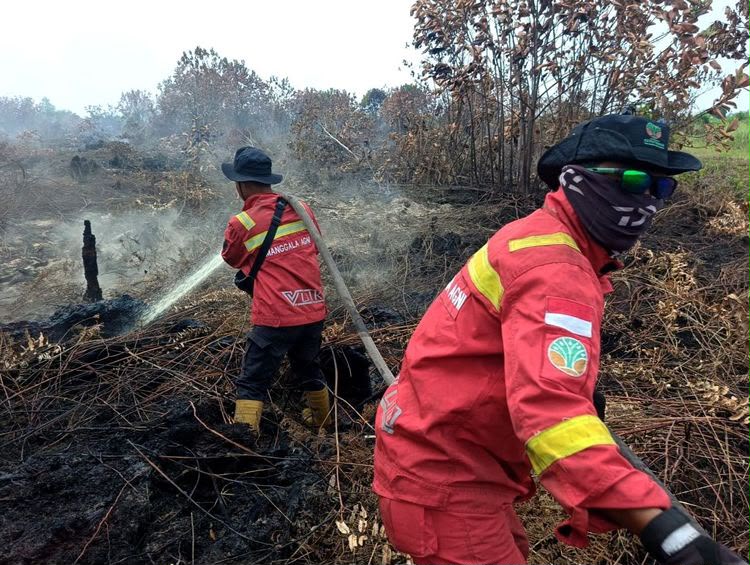
The Ministry reminds the public that satellite hotspots represent surface temperature anomalies rather than individual confirmed fires, requiring physical ground checks to verify conditions before field intervention. On the ground, Kemenhut’s Manggala Agni firefighters alongside the Military (TNI), National Police (Polri), BNPB, BMKG, BPBD, local governments, private concessionaires, and volunteer communities continue executing patrols, ground checks, direct firefighting, firebreak construction, mopping up, and cooling operations. Special attention is directed toward peatlands, where subterranean embers risk reigniting even when surface flames disappear.
Aerial support remains active, with 53 aircraft deployed across the six priority provinces. The fleet comprises 19 units dedicated to aerial patrols and Weather Modification Technology (OMC) operations, alongside 34 water-bombing units. Deployment strategy is continuously adjusted based on hotspot developments, ground check verifications, and real-time meteorological conditions.
Wildfire haze continues to impact regional air quality and visibility across key urban centers. PM2.5 monitoring indicates that parts of Kalimantan and Sumatra remain in the unhealthy to very unhealthy categories, with specific zones reaching hazardous levels. BMKG aviation weather data recorded hazy conditions and reduced visibility on Wednesday afternoon in Pontianak (approximately 2 kilometers), Jambi (3 kilometers), Pekanbaru (4 kilometers), Palangka Raya (4.5 kilometers), and Palembang (5 kilometers). In contrast, Banjarmasin recorded clearer conditions, with visibility at 9 kilometers under partly cloudy skies.
The Ministry of Forestry affirms that hotspot trajectories, active fire conditions, air quality readings, haze dispersion, weather forecasts, and rainfall data will be integrated continuously to guide upcoming operational priorities. Authorities reiterate their advisory urging citizens strictly to refrain from using fire for land clearing or preparation, and to report any smoke, hotspots, or fire indications immediately to ensure early containment. (*)